![Iventis_Pos_CMYK-1.jpg]](https://support.iventis.com/hs-fs/hubfs/Iventis_Pos_CMYK-1.jpg?height=50&name=Iventis_Pos_CMYK-1.jpg)
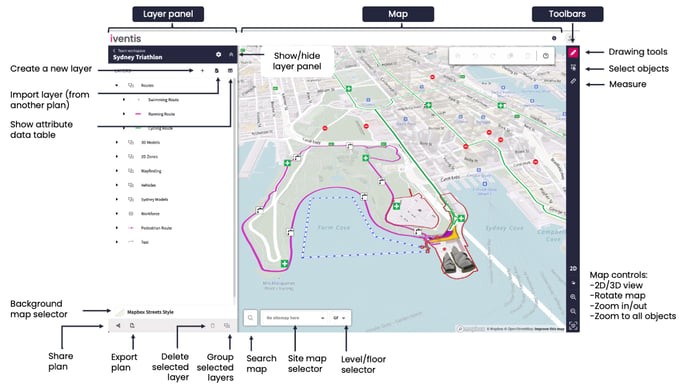
The map interface is made up of:
- The layer panel (left): Shows a list of layers in the map, allows you to create, delete and group layers.
- The map: The main canvas for viewing plans. You can zoom into the map using the controls on the bottom right or scrolling your mouse. You can pan by dragging the mouse, or using the arrow keys on your keyboard.
- Toolbars (right): Access tools to draw, select and measure on the map
Controlling the Map
You can pan and zoom around the map using your mouse, keyboard, or the navigation controls on the bottom right.
- Zooming into the map: Use the zoom buttons in the bottom right, your scroll wheel or by double clicking. You can pinch to zoom on mobile.
- Panning the map: Pan around the map by holding the mouse button and dragging your map. You can also use the arrow keys on your keyboard. You can drag using your finger on mobile.
- Rotate the map: Hold the right mouse and drag to rotate, or hold the ctrl key and drag your left mouse. You can reset to north by pressing the compass in the bottom right.
- Tilt the map in 3D: To tilt the map, hold your right mouse button and drag up and down. You can also hold the ctrl key and drag with the left mouse. You can also use the 2D/3D toggle in the bottom right