![Iventis_Pos_CMYK-1.jpg]](https://support.iventis.com/hs-fs/hubfs/Iventis_Pos_CMYK-1.jpg?height=50&name=Iventis_Pos_CMYK-1.jpg)
Size Options
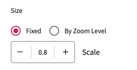
Icons sizes and line widths can be set either:
- As a fixed size which does not change when zooming in or out or;
- Variable by zoom level which can get bigger or smaller as the user zooms in/out
It is often useful to make icons smaller when you zoom out, to avoid them appearing clustered.
You can also hide icons entirely at certain zoom levels, such as when viewing the whole globe.
Adjusting Sizes
Within the layer settings panel, you can switch sizing from "fixed" to "by zoom level".
When sizing by zoom level, you can specify the size the icon/line should appear at each zoom level.
There are pre-defined zoom levels such as "At City Level" or "At Street Level". Here, you can specify the size at those zoom levels or hide the layer entirely at certain levels.

If you need more control, you can choose "Custom" zoom levels.
This allows you to specify the size at specific zoom levels. In Iventis, zoom levels are a number from 0-22. 22 is the maximum zoom level, and 0 is the minimum.
Note that the values must be added from lowest to highest zoom level.

To help pick specific zoom levels, you can see the current zoom level within the URL of the map. For example, the zoom level below would be 17.45.
![]()